1. Thermal Imaging
  2. Applications
  3. Aerial Ther­mo­graphy
Use of Infrared Cameras for Airborne Thermography of Large Areas

Aerial Ther­mo­graphy

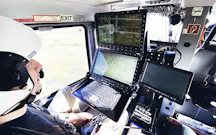
By using a helicopter equipped with an image stabilising gimbal, the infrared camera adds another dimension to the world of aerial thermography and the captured image data. An infrared camera in an elevated position provides an excellent thermographic overview for many fields of application. Depending on the task, aircraft as well as drones are also suitable as carriers and offer numerous options.

aerial-thermography-aerial-photography
Aerial thermography with infrared camera - Gimbal mount at helicopter
Aerial thermography with infrared camera
0 | 3

Possible Applic­a­tions of Ther­mo­graphic Flights

  • Aerial firefighting

  • Aerial fire mapping

  • Agricultural research and precision farming

  • Geo research with airborne infrared cameras

  • Thermal mapping with airborne camera platforms

  • Airborne inspection and maintenance of long-distance power lines

  • Wildlife counting and recording

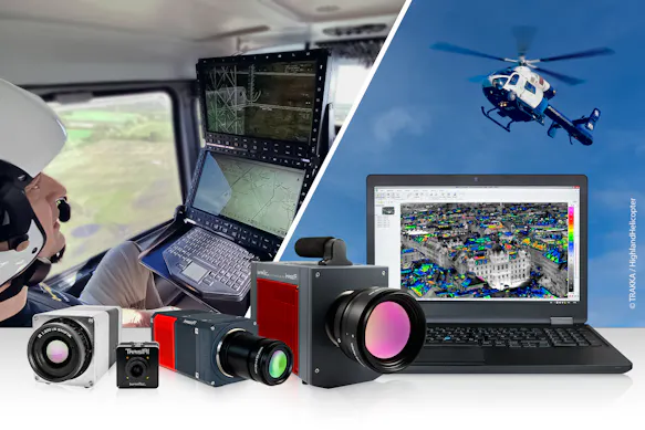
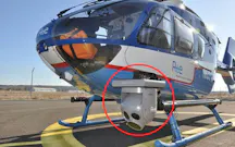
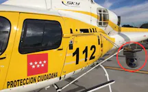
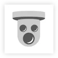
  • Gimbal systems for helicopter mounting

Event On Demand

High-Resol­u­tion Aerial Ther­mo­graphy

  • Aerial thermography: Definition, benefits, types, presence and future

  • Applications for thermography in airborne remote sensing and

  • Challenges of aerial thermography and technical requirements for an IR camera system

  • Important and relevant selection criteria

  • Accessories (hardware and software) needed to solve the measurement task

Request Recording

Infrared Cameras for Heli­copters and Aircraft

Are you looking for a “flying eye” in the infrared range? Your search has come to an end: InfraTec offers thermographic systems for use in a wide variety of airborne infrared applications and has been a reliable supplier of infrared cameras for over 30 years. InfraTec supports you as a competent partner in the implementation of your specific tasks in the field of airborne thermography.

Over­view of infrared cameras from InfraTec

Camera filter for infrared cameras

Infrared Cameras for other Airborne Thermal Imaging Projects

A cooperation with InfraTec takes you to the top – literally. If you're looking for a system partner that offers reliable, high-resolution infrared cameras for airborne systems, talk to the thermography experts at InfraTec. People who have been developing and manufacturing thermography solutions for over 30 years. Depending on the respective application, you can rely on different camera models or OEM developments.

Feel free to contact us if you would like to know more about a possible cooperation.

Learn more about ther­mo­graphy-based OEM solu­tions

OEM solutions from InfraTec - Integration
Contact to thermography division of InfraTec

Would You Like to Know More?

It is not unusual for tasks to be associated with special requirements. Discuss your specific application needs with our specialists, receive further technical information or learn more about our additional services.
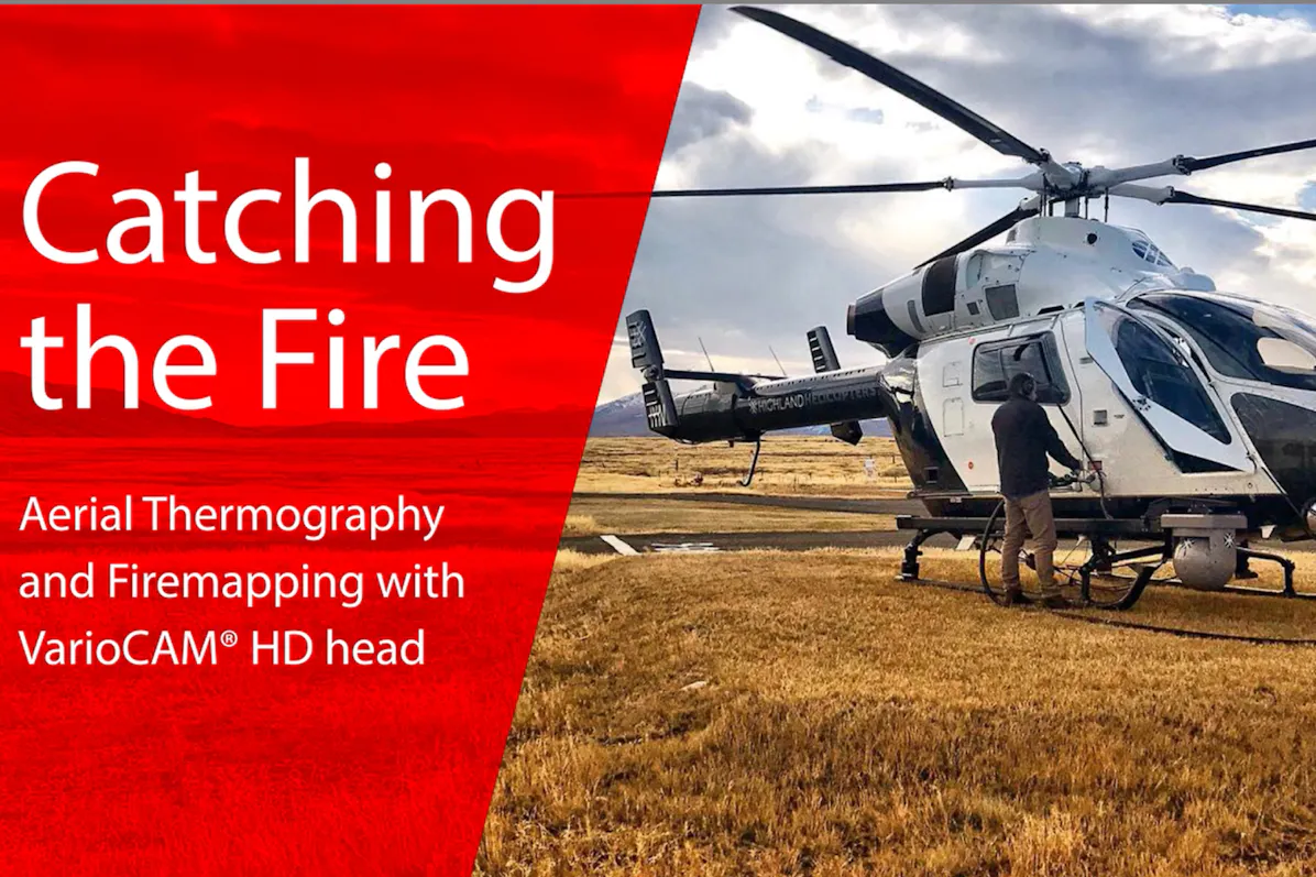
United Kingdom & Irland
InfraTec GmbH Infrarotsensorik und MesstechnikGostritzer Straße 61 - 6301217 DresdenGERMANY
InfraTec & Highland Helicopters - Aerial Fire Mapping ©Highland Helicopters Dunedin, New Zealand

Fire­fighting from the Air

An infrared camera can also be used to monitor the proper discharge of water containers from the air, as a form of primary forest firefighting. Even in the vicinity of smoke and flames, the distribution of firefighting water can be made visible due to the high thermal resolution of the infrared camera. This in turn allows the response team to quickly evaluate the efficiency of the water tank discharge and where there is still a need for more.

Numerous airborne reconnaissance systems enable InfraTec infrared cameras to provide reliable support for those risking their lives on the ground to fight fires. InfraTec's VarioCAM® HD and ImageIR® camera series are not just infrared cameras, but high-resolution, radiometrically calibrated thermographic systems. They therefore have the ability to measure temperatures even from a great distance. In addition, missing persons can be detected from the air.

InfraTec & Highland Helicopters - Aerial Fire Mapping ©Highland Helicopters Dunedin, New Zealand

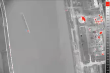
Aerial Fire Mapping / Fire Mapping

The number of bushfires and forest fires is increasing worldwide. Fighting them on the ground is made much more difficult by inaccessible terrain and the danger to life posed by the fire. In such cases, aerial fire mapping can provide a remedy. It provides a holistic overview and, with high-resolution thermographic systems, a reliable assessment of the situation. Based on the information gained, firefighting on the ground can be better coordinated and more targeted. Even in smoke, fog or poor visibility conditions, an infrared camera provides the most accurate data.

Airborne fire mapping is the best possible real-time tool for detecting and fighting forest fires. Helicopters are particularly suitable for this purpose, as their flexibility and manoeuvrability allow them to be used even in critical flight situations. In combination with a radiometrically calibrated infrared camera on board, experienced firefighters can quickly and reliably analyse the given situation from the air. Thermography can be used to create a ground temperature map in real time and generate a comprehensive overview of forest fires. The temperature measurements also make it possible to distinguish between burning forest, building structures and mammals or people trying to escape. Measurements on vehicles or industrial structures help to find other sources of dangerous fire.

Agri­cul­tural Research and Preci­sion Farming

Climate change is creating new challenges for modern agriculture. Lack of rain dries out soils and affects groundwater distribution. For a comprehensive soil assessment, an airborne thermography system can provide important data on the moisture content of the subsoil by recording soil temperature. This aerial monitoring helps to apply irrigation in the right places and avoid unnecessary waste of water. Airborne platforms, such as drones, with thermography systems are ideal for analysing soil moisture and other soil conditions comprehensively and from an elevated perspective. With the help of the collected thermographic measurement data, irrigation measures as well as plant growth can be assessed.

Infrared cameras of the VarioCAM® and ImageIR® series also support airborne crop research in the field of precision farming.

Geo Research with Airborne Infrared Cameras

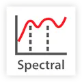
Infrared cameras are able to capture high-resolution infrared images from the air, regardless of visibility conditions, day or night. InfraTec's thermography systems operate in the mid (MWIR) and long wave infrared (LWIR), optional filtering can support spectral detail investigation of soil properties such as composition and thermal conductivity. Mineralogy, mining, basic research and the development of space sensors are geoscience applications that can be carried out by airborne thermography systems. But wildlife research also benefits from the results of aerial thermography, as the increased perspective allows for improved wildlife statistics, for example.

Aerial thermography with infrared camera

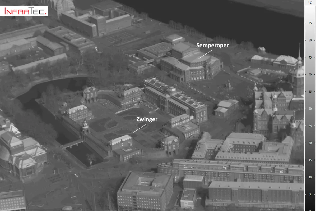
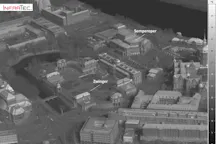
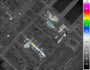
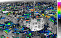
Thermal Mapping with Airborne Camera Plat­forms

Airborne thermal mapping is an essential tool to map the energy budget of individual municipalities on an area-by-area basis. In this way, efforts by municipalities to develop a zero-energy urbanity can be supported by collecting thermographic data quickly and efficiently. The VarioCAM® and ImageIR® infrared camera series provide the robust tools needed to record and collect the necessary thermographic data from aerial platforms such as drones.

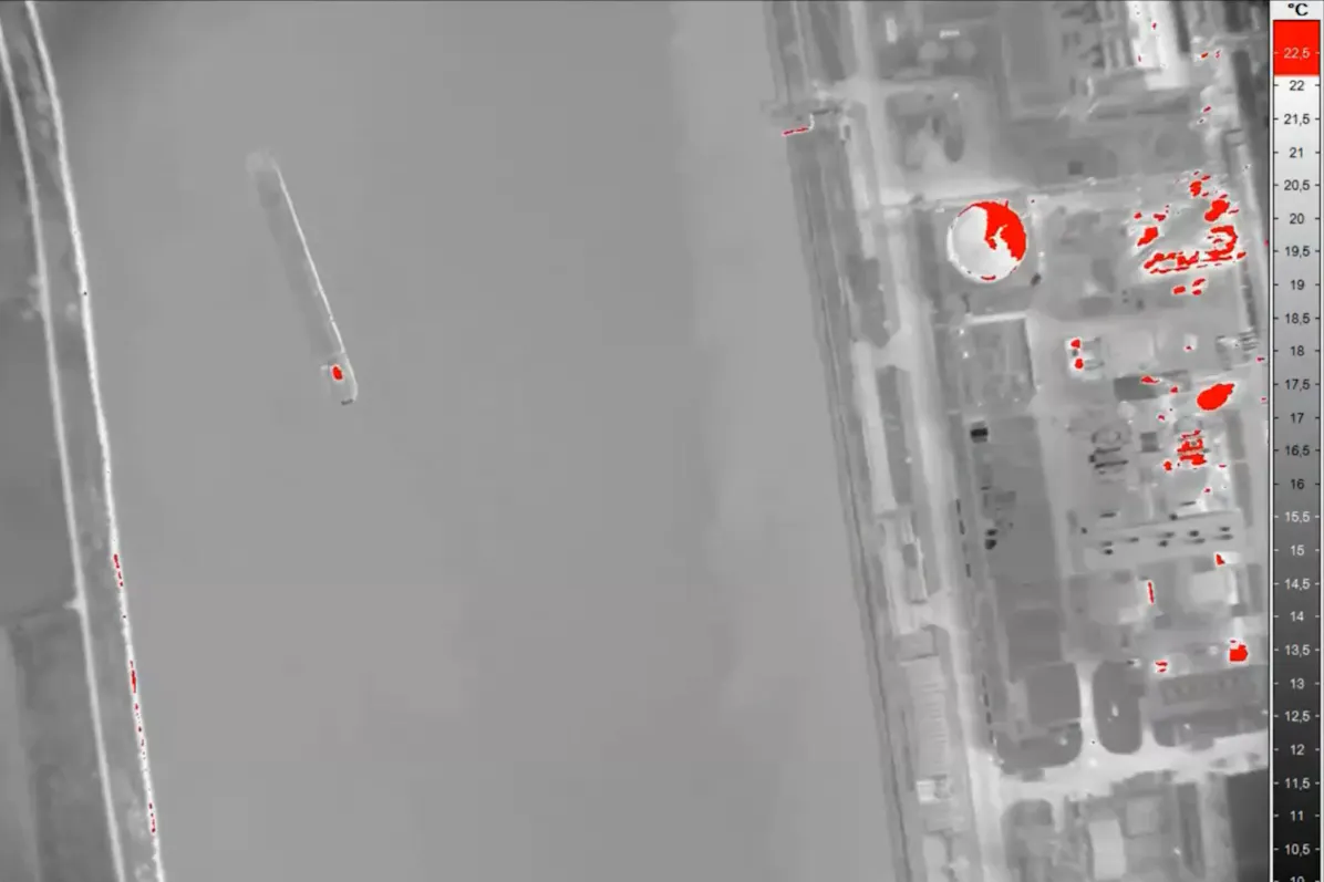
Furthermore, distributed heating networks require extended and efficient remote maintenance. With airborne thermography systems, an instant overview of the network's condition can be created. This allows teams on the ground to react immediately to defects and leaks using a thermal map created by the airborne monitoring platform.
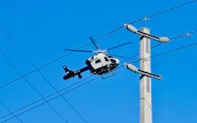
Aerial thermography - high voltage pylon

Airborne Inspec­tion and Main­ten­ance of Long-distance Power Lines

Electric long-distance power lines form the infrastructure backbone of any country. In order to safely meet the needs of the inhabitants and the local industry, trouble-free as well as uninterrupted availability is a must for power suppliers. To ensure this, infrared cameras are used, which are mounted on helicopters for inspection purposes. A proven inspection method for years.

The main task of the thermography system is to detect "hot spots" along the power line and on insulators. This detail is a proven indicator of material defects that can lead to system damage or failure. Thermography is also a reliable method for remote non-contact detection of hot spots in underground electrical cables, which also works perfectly from airborne platforms from an elevated position. Alternative visual inspections near the ground do not offer the speed and efficiency of an airborne thermographic inspection. When using video cameras or binoculars, the probability of detection is much lower and the movement from the air is much slower.

Aerial thermography with infrared camera - Gimbal mount at helicopter
Heli­copter with GIMBAL system front mounted
Aerial thermography with infrared camera
Over­flight of a detached house
aerial-thermography-aerial-photography
On-board work­sta­tions for checking data acquis­i­tion in real time, directly from the aircraft
Aerial thermography with infrared camera
Aerial ther­mo­graphy with an infrared camera
Aerial thermography with infrared camera - Inspection of long-distance power lines
Aerial ther­mo­graphy with an infrared camera
Aerial thermography with infrared camera
Flying over a city with an infrared camera
Aerial thermography with infrared camera - Gimbal mount at helicopter
Heli­copter with GIMBAL system rear mounted
Aerial thermography with infrared camera
Aerial survey of an indus­trial plant by means of an infrared camera

Case Studies for Airborne Ther­mo­graphy

Public­a­tions of our Customers

Die Luftnummer - Wildtierzählung aus der Vogelp­er­spektive

Infrared camera: VarioCAM® series

Optim­ized Data Acquis­i­tion with the IGI DigiTHERM Thermal Camera System

Infrared cameras in airborne remote sensing: IR-Imagery for photogrammetric processing at German Aerospace Center DLR, Berlin

First public­a­tion: QIRT 2012

Infrared cameras: ImageIR® 8300 and ImageIR® 8800

Advant­ages of this Ther­mo­graphy Solu­tions in this Applic­a­tion

Thermografie-Kameraserie ImageIR® mit neuer 10 GigE-Schnittstelle

10 GigE Inter­face for a Strong Increase in Output

The 10 Gigabit Ethernet interface of the high-end camera series ImageIR® opens this extremely fast transmission standard with a NIC specially developed by InfraTec. This works with optical or electrical transceiver modules that are easy to change and are called SFP+.

InfraTec glossary - Rotating filter- und aperture wheel

Separate Filter & Aper­ture Wheel – Spec­tral Ther­mo­graphy

The combination of a separate filter and aperture wheel, allowing a total of 35 freely selectable combinations, is prerequisite for an universal application in measurement tasks with high object temperatures and in the field of spectral thermography. The neutral density filters used for signal attenuation or the combination of spectral filters and apertures reliably prevent interference effects.

InfraTec Glossary Motorfocus

Motor Focus for ImageIR® Full Lenses – More Comfort

All interchangeable standard lens systems of the ImageIR® series can be combined with a motor focus unit, which is controlled by the camera operating software. It enables precise, remote and fast focusing. In addition, an autofocus function is available which operates reliably even with low image contrasts.

InfraTec Service - thermography lenses

High‐performance Full Optics

High quality precision lenses allow the adaptation of the image geometry to almost every measuring situation. Its performance parameters are calibrated with respect to functionality, quality and flexible application. Due to proper IR-transparent lens materials and high-precision antireflexion coating, the lenses are optimised for different spectral ranges.

InfraTec thermography - Geometrical Resolution

Geomet­rical Resol­u­tion – Effi­cient Analysis of Complex Assem­blies

InfraTec's infrared cameras with cooled and uncooled detectors have native resolutions up to (1,920 × 1,536) IR pixels. Spatially high-resolution thermograms ensure that components and assemblies are imaged down to the smallest detail and thus defects can be reliably detected and precisely localised.

InfraTec thermography - Thermal resolution

Thermal Resol­u­tion – Determ­in­a­tion of Differ­ences of Only a Few Millikelvin

For detection of small temperature changes InfraTec's infrared cameras offer thermal resolutions up to < 15 mK in real-time operation. By using the Lock-in Thermography method it is possible to further increase this resolution significantly. For this purpose test objects are periodically excited and non-destructively examined for defects and irregularities.

Integ­rated Trigger / Process Inter­face and Inter­faces – Digit­ally Controlling of a Infrared Camera and External Devices

The internal trigger interface guarantees highly precise, repeatable triggering. Each of the two configurable digital inputs and outputs are used to control the camera or to generate digital control signals for external devices. In this way, for example, the operation of a printed circuit board and the interval of a measurement can be synchronised.

The selection of different camera interfaces allows the processing of analog data, such as the voltage directly through the camera and thus the insertion of this information into the thermal image data. Relevant variables can be included in the evaluations with the software, which makes it easier to draw conclusions about the causes of temperature changes.

Ther­mo­graphy Solu­tions from InfraTec

Relevant Infrared cameras from InfraTec

The high measurement accuracy of the camera series VarioCAM® and ImageIR® required for applications in the field of aerial thermography is the result of more than 30 years of experience in the development of thermographic systems. Numerous scientific cooperations and participations in research projects as well as the regular exchange with our customers and partners enable us to optimally adapt our infrared cameras to your requirements.

Discover the variety of InfraTec infrared cameras
Further details about high-end camera series ImageIR®
Further details about camera series Vari­oCAM® High Defin­i­tion

Gimbal Systems for Heli­copter Mounting

InfraTec offers various infrared camera systems for fixed mount use in airplanes as well as for integration into precision gimbals. Thereby, the infrared camera can be exactly positioned within a µrad range to track automatically. A handy remote control allows for camera operation directly via the control of the gimbal.

Gimbals, or gyro-stabilized platforms, have been used for many years as very effective systems for airborne thermography in the inspection of high-voltage power lines, pipelines and industrial plants, as well as in the search for energy and material pollution.

Gimbal for helicopter mount

Due to their high-precision stabilization, images of distant objects can be accurately captured despite movement of the airborne vessel carrying the gimbal. Integrated into the gimbal are cameras for both, the visible (visual camera) and in the infrared radiation spectrum (infrared camera), a laser rangefinder and laser target designators.

Flyer Gimbal system for helicopter mount

Advant­ages of the Vari­oCAM® High Defin­i­tion and ImageIR® Camera Series

InfraTec Icon Gimbal
Easy integration

into gyro-stabilised gimbal systems of helicopters, aeroplanes, drones or other aerial platforms

InfraTec-icon-detector-1920x1536
High-resolution

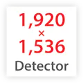
thermographic systems in HD format with (1,024 x 768) to (1,920 x 1,536) IR pixels
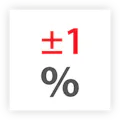
measurement accurancy 1%
Highest measurement accuracy

of ± 1 °C / ± 1 %

Full frame rates up to 1,000 HZ
Full frame rates

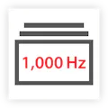
up to 1,000 Hz for fast and efficient monitoring missions

infraTec icon optics
Wide range

of infrared lenses for optimal field of view adjustment

InfraTec-icon-spectralthermography
Spectral filtering

possible

IP54
Robust industrial camera design

(IP54 to IP67) with protection grade LEMO® connectors for secure data transmission and uninterrupted availability

InfraTec Icon Trigger
Trigger interfaces

for GPS synchronisation and connectivity to inertial measurement systems

Infrared Cameras for Aerial Ther­mo­graphy

InfraTec Infrared camera
Zoom Cameras

ImageIR® 6300 Z

Image Format(640 x 512) IR-Pixel
Detector typeXBn

InfraTec Infrared camera
High-end Cameras

ImageIR® 8300 hs

Image Format(640 x 512) IR-Pixel
Detector typeT2SLS or InSb

InfraTec Infrared camera
Zoom Cameras

VarioCAM® HD Z

Image Format(1,024 x 768) IR-Pixel
Detector typeUncooled Microbolometer Focal Plane Array

InfraTec Infrared camera
High-end Cameras

ImageIR® 9400 hp

Image Format(2,560 x 2,048) IR-Pixel
Detector typeInSb

InfraTec Infrared camera
High-end Cameras

ImageIR® 10300

Image Format(1,920 x 1,536) IR-Pixel
Detector typeInSb

InfraTec Infrared camera
Compact Cameras

PIR uc 605

Image Format(640 x 480) IR-Pixel
Detector typeUncooled Microbolometer Focal Plane Array

InfraTec Infrared camera
High-end Cameras

ImageIR® 9500

Image Format(2,560 x 1,440) IR-Pixel
Detector typeMCT

InfraTec Infrared camera
Zoom Cameras

VarioCAM® HD Z security

Image Format(1,024 x 768) IR-Pixel
Detector typeUncooled Microbolometer Focal Plane Array

InfraTec Infrared camera
High-end Cameras

ImageIR® 9400

Image Format(2,560 x 2,048) IR-Pixel
Detector typeInSb

InfraTec Infrared camera
System Cameras

VarioCAM® HDx head S

Image Format(640 x 480) IR-Pixel
Detector typeUncooled Microbolometer Focal Plane Array

InfraTec Infrared camera
High-end Cameras

ImageIR® 9400 hs

Image Format(640 x 512) IR-Pixel
Detector typeInSb

InfraTec Infrared camera
System Cameras

PIR uc LWIR 600

Image Format(640 x 480) IR-Pixel
Detector typeUncooled microbolometer focal-plane array

InfraTec Infrared camera
High-end Cameras

ImageIR® 9300

Image Format(1,280 x 1,024) IR-Pixel
Detector typeInSb

InfraTec Infrared camera
System Cameras

VarioCAM® HDx head 600

Image Format(640 x 480) IR-Pixel
Detector typeUncooled Microbolometer Focal Plane Array

InfraTec Infrared camera
High-end Cameras

ImageIR® 8300 hp

Image Format(1,280 x 1,024) IR-Pixel
Detector typeMCT or InSb

InfraTec Infrared camera
High-end Cameras

ImageIR® 8800

Image Format(1,280 x 1,024) IR-Pixel
Detector typeMCT

InfraTec Infrared camera
High-end Cameras

ImageIR® 8300

Image Format(640 x 512) IR-Pixel
Detector typeMCT or InSb

10.000,00 €

TEST

InfraTec Infrared camera
High-end Cameras

ImageIR® 5300

Image Format(320 x 256) IR-Pixel
Detector typeMCT

InfraTec Infrared camera
System Cameras

VarioCAM® HD head 800

Image Format(1,024 x 768) IR-Pixel
Detector typeUncooled Microbolometer Focal Plane Array

Ther­mo­graphy Soft­ware for Analysing the Data

Aerial thermography with infrared camera - Notebook

VarioCAM® and ImageIR® thermography systems offer as an additional advantage the innovative IRBIS® 3 software with a comprehensive range of functions as an indispensable tool for demanding thermography tasks. This software is the ideal instrument for fast analysis of thermographic measurement data and for convenient creation of thermographic reports.

Advant­ages of IRBIS® Soft­ware
  • Numerous analysis functions and tools

  • Extensive visual representations of the measurement data

  • Professional creation of thermographic reports

  • Convenient camera control and data acquisition

  • Modular concept enables application-specific configurations

  • SDK enables camera integration into existing systems

Real-time Data Acquis­i­tion is Ensured via our IRBIS® Online Soft­ware
  • Data storage takes place at the camera's maximum frame rate

  • Online differential image mode and temperature profile display

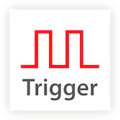
  • External trigger option, retrigger, multiple signal sequence, pretrigger

  • Freely definable temperature trigger

  • Parameterisation of measuring fields and threshold values, alarm function

Further inform­a­tion about the IRBIS® 3 soft­ware

Infrared Solutions from InfraTec

FLIR – Forward Looking InfraRed

The term FLIR stands for the abbreviation Forward Looking InfraRed. The abbreviation FLIR originated in the course of the further development of the infrared camera at the beginning of the 1960s. Originally a one-dimensional downward or sideways looking system on aircraft, it was then replaced by forward looking scanner cameras that no longer relied on movement of the carrier system for imaging.

Modern FLIR are equipped with different cooled and uncooled two-dimensional imaging detector systems that reproduce thermal images in the wavelength ranges of (2 ... 14) µm. This makes FLIR ideal for people and vehicle detection in government applications, other applications include industrial and aerial thermography.